Construction
Construction sites are dynamic, complex, and constantly changing. Aerial photography and video gives project managers, owners, and contractors a real-time view of the entire site that no ground-based camera — and no site walk — can match. From roofing and renovation to large-scale building projects, NE Ohio Drone provides professional aerial documentation that keeps everyone informed and on the same page.
Scheduled aerial documentation on a recurring basis — weekly, bi-weekly, or monthly — gives you a consistent visual record of site progress from the same angles at every visit. Retainer arrangements are available for Northeast Ohio projects and are structured around your schedule and site conditions. Weather-dependent flexibility is built in. Contact Ed Rich directly to discuss a program that fits your project timeline and budget.
How professional drone photography transforms construction project management, communication, and documentation.
What Aerial Photography Delivers on a Construction Site
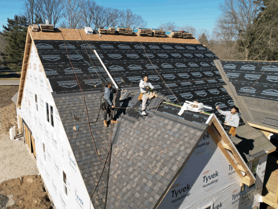
Document roofing projects from above at every stage — tear-off, decking, installation, and completion. Aerial photography captures the full scope of the work in progress, confirms material coverage and crew positioning, and provides a permanent photographic record of what was done and when. Invaluable for contractor liability documentation and owner sign-off.
A single aerial image captures more site information than hours of ground-level walkthrough documentation. Shot from consistent angles on a scheduled basis, progress photos give owners, lenders, and project managers a clear, verifiable record of where the project stands at every milestone — without requiring a site visit.
Nothing communicates project momentum to investors, lenders, and ownership groups like a well-produced aerial progress video. Show the site from above at key milestones — foundation, framing, envelope, finish — and deliver a visual report that written updates simply cannot match. Edited and ready to present within 24 hours of the shoot.
High-resolution aerial stills provide accurate spatial context for planning decisions — material staging areas, equipment positioning, access routes, and site boundaries. Seeing the full site from above surfaces logistical issues that aren't visible from the ground until they become expensive problems.
Aerial photography of a project under construction is one of the most effective pre-leasing and pre-sales tools available. Showing a prospective tenant or buyer the scale of the development, its location context, and its progress builds confidence and drives commitment before the building is even complete.
Comprehensive aerial photo documentation before, during, and after a project creates an indisputable visual record that protects all parties in the event of a dispute, damage claim, or insurance issue. Dated, geotagged aerial imagery from a licensed operator carries weight that smartphone photos do not.
Tell us about your project, your location, and how often you need coverage — we'll get back to you promptly.