Controlled Airspace
Controlled airspace is any airspace where Air Traffic Control (ATC) is actively managing the movement of aircraft. Airports of all sizes sit at the center of controlled airspace rings, and the rules governing drone operations within those rings are strict, specific, and federally enforced.
The map below shows the controlled airspace over Northeast Ohio. The rings and shaded areas around each airport represent different airspace classes — each with its own rules, altitude limits, and authorization requirements. Understanding this map is part of what separates a licensed Part 107 pilot from someone who just bought a drone.
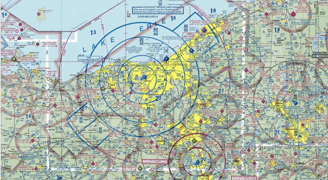
For commercial drone pilots, operating in any of this airspace without proper authorization is a violation of federal law. The airspace over the greater Cleveland and Akron metro area is among the most layered in Ohio — and Ed Rich is trained, certified, and authorized to operate within it.
Airspace Classifications That Affect Drone Operations
Surrounds the region's busiest commercial airport. Drone operations require both LAANC approval and specific ATC clearance. The most restrictive airspace class in the area.
Moderate-traffic airport with an operating radar facility. Requires two-way ATC communication and authorization before drone entry.
Smaller airports with an operating control tower, including Burke Lakefront (BKL). Requires pilot coordination with the tower before operations begin.
Controlled airspace extending to lower altitudes across large portions of Northeast Ohio. LAANC authorization required for drone operations below 400 feet AGL.
Reading Aeronautical Charts
Sectional aeronautical charts are the FAA's official maps of the national airspace. They show airspace classifications, airport locations, terrain, obstacles, and restricted areas — all in a standardized format that licensed pilots are trained and tested on. Knowing how to read a sectional chart is a core competency tested on the FAA Part 107 knowledge exam.
Recreational fliers are not trained in chart reading and have no legal mechanism to obtain controlled airspace authorization for commercial purposes. That's not a technicality — it's the fundamental divide between a licensed commercial pilot and a hobbyist.